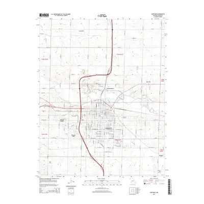
2015 Map of Carthage
USGS Topo · Published 2015About this map
Carthage serves as the central hub of this 2015 survey, situated where the Spring River and Kellogg Lake define the local topography. The city's grid is dense with street-level detail, reflecting its role as a regional center in Jasper County. To the north and west, smaller communities like Kendricktown, Carytown, and Morgan Heights illustrate the residential expansion beyond the city core. The inclusion of Civil War Ave and Civil War Rd provides a clear nod to the region's nineteenth-century history, while modern transport is represented by the massive interchange of Highway 71 and Interstate 49.
Find a feature on this map
145 named features on this map. Tap any name to fly to it.
Don’t see what you’re looking for? This feature index may not catch every label — zoom into the map to look around manually.
Map Details
Editions of this 2015 Carthage Map
This is the sole edition of this map. No revisions or reprints were ever made.
Other maps of this area

1886 · Carthage
USGS Topo · 1:125,000

1894 · Carthage
USGS Topo · 1:125,000

1921 · Sarcoxie
USGS Topo · 1:62,500

1947 · Joplin
USGS Topo · 1:250,000

1949 · Joplin
USGS Topo · 1:250,000

1954 · Joplin
USGS Topo · 1:250,000

1958 · Joplin
USGS Topo · 1:250,000

1959 · Joplin
USGS Topo · 1:250,000
1962 · Jasper
USGS Topo · 1:24,000
1962 · Neck City
USGS Topo · 1:24,000