1962 Map of Neck City
USGS Topo · Published 1963About this map
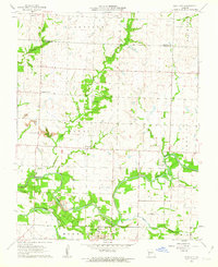
Neck City and the surrounding mining district of Jasper County are documented here in the early 1960s, showing a landscape heavily modified by lead and zinc extraction. Prominent Tailings piles and numerous Mines are clustered south of the North Fork Spring River, particularly near the Old Railroad Grade. This industrial footprint contrasts with the agricultural character of the northern half of the map, where small settlements like Cossville and Nashville persist near the Barton County line.
Find a feature on this map
27 named features on this map. Tap any name to fly to it.
Don’t see what you’re looking for? This feature index may not catch every label — zoom into the map to look around manually.
Map Details
Editions of this 1962 Neck City Map
2 editions found

Other maps of this area

1886 · Joplin
USGS Topo · 1:125,000

1886 · Carthage
USGS Topo · 1:125,000

1894 · Joplin
USGS Topo · 1:125,000

1894 · Carthage
USGS Topo · 1:125,000

1945 · Pittsburg
USGS Topo · 1:62,500

1947 · Joplin
USGS Topo · 1:250,000

1947 · Pittsburg
USGS Topo · 1:62,500

1949 · Joplin
USGS Topo · 1:250,000
1950 · Pittsburg
USGS Topo · 1:62,500

1954 · Joplin
USGS Topo · 1:250,000