
1962 Map of Neck City
USGS Topo · Published 1991About this map
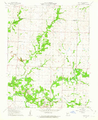
Neck City and the surrounding mining district of Jasper and Barton Counties are meticulously documented in this early 1960s survey. The landscape is defined by the North Fork Spring River and its tributaries, including Duval Creek and Slater Branch. One of the most striking visual elements is the presence of Tailings piles near the riverbank, indicating the heavy lead and zinc mining legacy of the Tri-State district. Rural life centers on small settlements like Cossville and Tuckers Corner, while the decommissioned Old Railroad Grade traces the former path of industrial transport across Mineral township. Local genealogists will find several burial grounds mapped, such as Shapley Cem and Cedar Bluff Cem, alongside the New Providence Ch, providing a clear view of the area's social and religious centers before major modern alterations.
Find a feature on this map
24 named features on this map. Tap any name to fly to it.
Don’t see what you’re looking for? This feature index may not catch every label — zoom into the map to look around manually.
Map Details
Editions of this 1962 Neck City Map
2 editions found
Other maps of this area

1886 · Joplin
USGS Topo · 1:125,000

1886 · Carthage
USGS Topo · 1:125,000

1894 · Joplin
USGS Topo · 1:125,000

1894 · Carthage
USGS Topo · 1:125,000

1945 · Pittsburg
USGS Topo · 1:62,500

1947 · Joplin
USGS Topo · 1:250,000

1947 · Pittsburg
USGS Topo · 1:62,500

1949 · Joplin
USGS Topo · 1:250,000
1950 · Pittsburg
USGS Topo · 1:62,500

1954 · Joplin
USGS Topo · 1:250,000