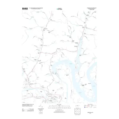
2013 Map of Carthage
USGS Topo · Published 2013About this map
Carthage sits at a historic river junction where the Cumberland River meets Hogan Cr and Turkey Cr, serving as a focal point for the region's agricultural and river-based economy. The geography is defined by the significant winding of the river, notably at Horseshoe Bend and McClures Bend, where the terrain drops to Myers Bottom and rises to prominent overlooks like Petty Bluff. The creation of the Cordell Hull Reservoir has significantly altered the landscape, submerging previous bottomlands while creating a new shoreline that follows the intricate contours of old hollows.
Find a feature on this map
156 named features on this map. Tap any name to fly to it.
Don’t see what you’re looking for? This feature index may not catch every label — zoom into the map to look around manually.
Map Details
Editions of this 2013 Carthage Map
This is the sole edition of this map. No revisions or reprints were ever made.
Other maps of this area

1928 · Gordonsville
USGS Topo · 1:62,500

1932 · Carthage
USGS Topo · 1:62,500

1942 · Statesville
USGS Topo · 1:100,000

1956 · Corbin
USGS Topo · 1:250,000

1956 · Nashville
USGS Topo · 1:250,000

1958 · New Middleton
USGS Topo · 1:24,000

1958 · Corbin
USGS Topo · 1:250,000

1958 · Dixon Springs
USGS Topo · 1:24,000

1959 · Nashville
USGS Topo · 1:250,000
1959 · Hillsdale
USGS Topo · 1:24,000