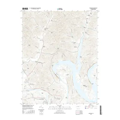
2016 Map of Carthage
USGS Topo · Published 2016About this map
The Cumberland River and the broad waters of the Cordell Hull Reservoir dominate the landscape of Smith County in this 2016 survey. The county seat of Carthage and its neighbor South Carthage sit at the southern bend of the river, while the surrounding hills are marked by a network of hollows bearing family names such as Tony Hollow, Brooks Hollow, and Nixon Hollow. The topography is defined by dramatic river features, including Horseshoe Bend, McClures Bend, and the high ground of Tater Knob.
Find a feature on this map
121 named features on this map. Tap any name to fly to it.
Don’t see what you’re looking for? This feature index may not catch every label — zoom into the map to look around manually.
Map Details
Editions of this 2016 Carthage Map
This is the sole edition of this map. No revisions or reprints were ever made.
Other maps of this area

1928 · Gordonsville
USGS Topo · 1:62,500

1932 · Carthage
USGS Topo · 1:62,500

1942 · Statesville
USGS Topo · 1:100,000

1956 · Corbin
USGS Topo · 1:250,000

1956 · Nashville
USGS Topo · 1:250,000

1958 · New Middleton
USGS Topo · 1:24,000

1958 · Corbin
USGS Topo · 1:250,000

1958 · Dixon Springs
USGS Topo · 1:24,000

1959 · Nashville
USGS Topo · 1:250,000
1959 · Hillsdale
USGS Topo · 1:24,000