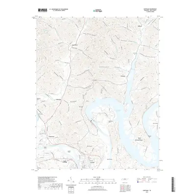
2019 Map of Carthage
USGS Topo · Published 2019About this map
Carthage and South Carthage anchor this landscape where the Cumberland River meets the expansive waters of the Cordell Hull Reservoir. The terrain is defined by a dense network of steep ridges and named hollows, including Friendship Hollow, Brooks Hollow, and Dillehay Hollow, which reflect long-standing family landholdings and localized communities. To the north, the curiously named settlements of Defeated and Difficult sit along the winding paths of Defeated Cr and Cromwell Br, hinting at the challenging topography that early settlers encountered.
Find a feature on this map
122 named features on this map. Tap any name to fly to it.
Don’t see what you’re looking for? This feature index may not catch every label — zoom into the map to look around manually.
Map Details
Editions of this 2019 Carthage Map
This is the sole edition of this map. No revisions or reprints were ever made.
Other maps of this area

1928 · Gordonsville
USGS Topo · 1:62,500

1932 · Carthage
USGS Topo · 1:62,500

1942 · Statesville
USGS Topo · 1:100,000

1956 · Corbin
USGS Topo · 1:250,000

1956 · Nashville
USGS Topo · 1:250,000

1958 · New Middleton
USGS Topo · 1:24,000

1958 · Corbin
USGS Topo · 1:250,000

1958 · Dixon Springs
USGS Topo · 1:24,000

1959 · Nashville
USGS Topo · 1:250,000
1959 · Hillsdale
USGS Topo · 1:24,000