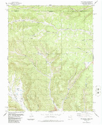
1986 Map of Casa Grande
USGS Topo · Published 1986About this map
The Beaubien and Miranda Grant (Maxwell) dominates this landscape in northern Colfax County, where the high mesas of the Sangre de Cristo foothills meet industrial resource extraction. The settlement at Casa Grande and nearby Bartlett sit along the Vermejo River, anchored by agricultural and mining activity. The map reveals an intensive history of land use, from the Old Railroad Grade tracing the Canadian River to the extensive Strip Mine and numerous mines and Air Shafts concentrated in York Canyon. This area represents a complex geography of Spanish land grants and modern energy production, where deep canyons like Penitente Canyon and Stubblefield Canyon cut through high plateaus marked by Butler Flats and numerous Prospects. The transition from Colorado into New Mexico is clearly defined along the northern boundary, marking the divide between Las Animas and Colfax Counties.
Find a feature on this map
35 named features on this map. Tap any name to fly to it.
Don’t see what you’re looking for? This feature index may not catch every label — zoom into the map to look around manually.
Map Details
Editions of this 1986 Casa Grande Map
This is the sole edition of this map. No revisions or reprints were ever made.
Other maps of this area

1891 · Spanish Peaks
USGS Topo · 1:125,000

1893 · Spanish Peaks
USGS Topo · 1:125,000

1895 · Spanish Peaks
USGS Topo · 1:125,000

1897 · Spanish Peaks
USGS Topo · 1:125,000

1900 · Spanish Peaks
USGS Topo · 1:125,000

1954 · Raton
USGS Topo · 1:250,000

1954 · Trinidad
USGS Topo · 1:250,000

1955 · Trinidad
USGS Topo · 1:250,000

1958 · Raton
USGS Topo · 1:250,000

1958 · Trinidad
USGS Topo · 1:250,000