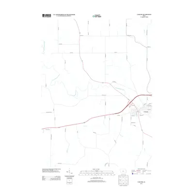
2013 Map of Cascade
USGS Topo · Published 2013About this map
Cascade sits as the central hub of this 2013 landscape, positioned where the N Fork Maquoketa River winds through the eastern portion of the quadrangle. The town's grid is well-defined by streets such as Riverview Rd and 3rd Ave SW, showing the modern footprint of this riverfront community. To the west, the historic settlement of Bowens Prairie remains a notable point of interest, situated near the headwaters of Tibbetts Cr. The surrounding countryside is defined by an intricate network of rural routes and natural drainage, including Jordan Cr and Farm Cr. Grounded in the 2011 NAIP imagery and 2012 GNIS data, this map captures the contemporary road system from Co Hwy-Y13 in the north to the family-named landmarks like Goose Hill Rd and Schemmel Rd.
Find a feature on this map
52 named features on this map. Tap any name to fly to it.
Don’t see what you’re looking for? This feature index may not catch every label — zoom into the map to look around manually.
Map Details
Editions of this 2013 Cascade Map
This is the sole edition of this map. No revisions or reprints were ever made.
Other maps of this area

1891 · Monticello
USGS Topo · 1:62,500

1891 · Baldwin
USGS Topo · 1:62,500

1900 · Anamosa
USGS Topo · 1:125,000

1901 · Peosta
USGS Topo · 1:125,000

1959 · Dubuque
USGS Topo · 1:250,000

1961 · Dubuque
USGS Topo · 1:250,000

1962 · Dubuque
USGS Topo · 1:250,000
1965 · Dyersville West
USGS Topo · 1:24,000
1965 · Dyersville East
USGS Topo · 1:24,000
1966 · Fillmore
USGS Topo · 1:24,000