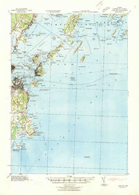
1941 Map of Casco Bay
USGS Topo · Published 1941About this map
The harbor defenses of Portland dominate this 1941 tactical map, featuring a chain of coastal fortifications including Fort McKinley, Fort Gorges, and Fort Preble. Revised from aerial photography just before the United States' entry into World War II, the sheet illustrates the strategic significance of the islands and headlands protecting Portland and South Portland. Maritime safety is marked by several primary beacons, from the Portland Head Lighthouse at Fort Williams to the isolated Halfway Rock Lighthouse and the Portland Lightship stationed far offshore.
Find a feature on this map
147 named features on this map. Tap any name to fly to it.
Don’t see what you’re looking for? This feature index may not catch every label — zoom into the map to look around manually.
Map Details
Editions of this 1941 Casco Bay Map
This is the sole edition of this map. No revisions or reprints were ever made.
Other maps of this area

1891 · Portland
USGS Topo · 1:62,500

1891 · Biddeford
USGS Topo · 1:62,500

1892 · Freeport
USGS Topo · 1:62,500

1893 · Biddeford
USGS Topo · 1:62,500

1893 · Small Point
USGS Topo · 1:62,500

1893 · Portland
USGS Topo · 1:62,500

1893 · Casco Bay
USGS Topo · 1:62,500

1894 · Gray
USGS Topo · 1:62,500

1894 · Bath
USGS Topo · 1:62,500

1898 · Gray
USGS Topo · 1:62,500