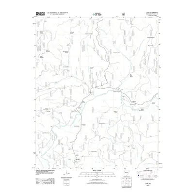
2011 Map of Cass
USGS Topo · Published 2011About this map
The Mulberry River carves a deep path through this Franklin County landscape, acting as the central artery for small settlements like Cass and Redding. The 2011 survey reveals a region defined by its rugged topography, where numerous hollows such as Eureka Springs Hollow and McBurrel Hollow drain into a complex network of creeks. This map is particularly valuable for genealogical research, documenting several family-named burial sites including Mcilroy Cemetery, Plymale Cemetery, and Childers Cemetery. High points like Whiting Mountain and the Fly Gap Lookout Tower provide orientation in the dense terrain. The presence of the Bee Rock Point of Interest and Devils Den Hollow highlights the area's geological character, while scattered settlements like Barnes and Paradise remain connected by forest service and county roads.
Find a feature on this map
69 named features on this map. Tap any name to fly to it.
Don’t see what you’re looking for? This feature index may not catch every label — zoom into the map to look around manually.
Map Details
Editions of this 2011 Cass Map
This is the sole edition of this map. No revisions or reprints were ever made.
Other maps of this area

1879 · Cravens
USGS Topo · 1:62,500

1887 · Watalula
USGS Topo · 1:62,500

1906 · Batson
USGS Topo · 1:62,500

1939 · Watalula
USGS Topo · 1:62,500

1943 · St. Paul
USGS Topo · 1:62,500

1946 · St. Paul
USGS Topo · 1:62,500

1956 · Russellville
USGS Topo · 1:250,000
1963 · Hunt
USGS Topo · 1:24,000

1964 · Russellville
USGS Topo · 1:250,000
1973 · Cravens
USGS Topo · 1:24,000