
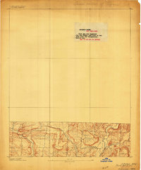
1906 Map of Batson
USGS Topo · Published 1906About this map
Mulberry Mountain and the surrounding southern highlands of Johnson County are documented in this unique advance sheet, produced for the State of Arkansas before standard publication. The small settlements of Harmony, Hunt, and Grace are situated within a landscape defined by significant elevation changes and the drainage of the East Fork of Horse Head Creek. The map provides a rare look at the area's early 20th-century geography, illustrating how local roads and habitations followed the natural contours of the Ridge and the prominent heights of Philpott. Because this specific engraving was originally intended as a restricted office copy, it captures the raw topographic data of the region at a time when rural mountain communities were largely isolated from broader transportation networks.
Find a feature on this map
7 named features on this map. Tap any name to fly to it.
Don’t see what you’re looking for? This feature index may not catch every label — zoom into the map to look around manually.
Map Details
Editions of this 1906 Batson Map
This is the sole edition of this map. No revisions or reprints were ever made.
Other maps of this area

1879 · Cravens
USGS Topo · 1:62,500

1887 · Magazine Mountain #1
USGS Topo · 1:62,500

1887 · Magazine Mountain #2
USGS Topo · 1:62,500

1887 · Watalula
USGS Topo · 1:62,500

1887 · Magazine Mountain
USGS Topo · 1:62,500

1888 · Dardanelle #2
USGS Topo · 1:62,500
1889 · Ozone
USGS Topo · 1:62,500

1890 · Magazine Mountain
USGS Topo · 1:125,000

1890 · Dardanelle
USGS Topo · 1:125,000
1934 · Ozone
USGS Topo · 1:62,500