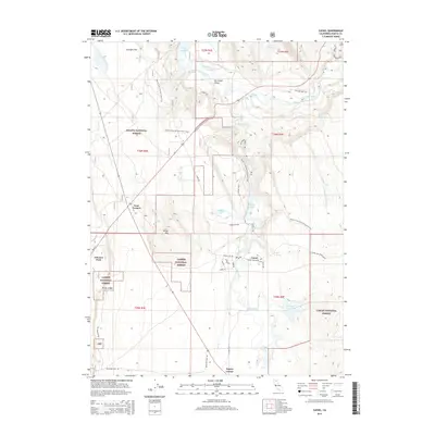
2015 Map of Cassel
USGS Topo · Published 2015About this map
Cassel and the surrounding volcanic plateau of northeastern California are defined by a complex network of waterways including the Pit River and Hat Creek. This landscape, situated between the Shasta National Forest and Lassen National Forest, shows a clear pattern of utility and recreation in the mid-2010s. The presence of the Pit Number 1 Powerhouse Rd and Chalk Reservoir indicates the importance of hydroelectric development in this region. Further south, the map traces the spring-fed waters of the Rising River and Rising River Lake, alongside small clusters of settlement at Johnson Park and Doyles Corner. The Pacific Crest National Scenic Trail winds through the varied terrain of Arkright Flat and Hat Creek Valley, illustrating the area's significance for long-distance hiking and public land management.
Find a feature on this map
37 named features on this map. Tap any name to fly to it.
Don’t see what you’re looking for? This feature index may not catch every label — zoom into the map to look around manually.
Map Details
Editions of this 2015 Cassel Map
This is the sole edition of this map. No revisions or reprints were ever made.
Other maps of this area

1886 · Lassen Peak
USGS Topo · 1:250,000

1886 · Modoc Lava Bed
USGS Topo · 1:250,000

1892 · Modoc Lava-Bed
USGS Topo · 1:250,000

1892 · Lassen Peak
USGS Topo · 1:250,000

1894 · Lassen Peak
USGS Topo · 1:250,000

1932 · Bartle
USGS Topo · 1:96,000

1935 · Burney
USGS Topo · 1:96,000

1939 · Burney
USGS Topo · 1:125,000

1939 · Halls Flat
USGS Topo · 1:125,000

1939 · Bartle
USGS Topo · 1:125,000