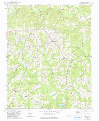
1979 Map of Castalia
USGS Topo · Published 1979About this map
The rural landscape of the Franklin and Nash County line centers on the historic settlement of Castalia. This area is defined by a network of crossroads communities that were essential to the region's agricultural economy, including Lancaster Crossroads, Matthews Crossroads, Mays Crossroads, and Edwards Crossroads. The terrain is drained by several prominent waterways, such as Red Bud Creek in the north and the uniquely named Pig Basket Creek in the east. Local history is anchored by longstanding spiritual centers like Cedar Rock Ch, Bethlehem Ch, and St Delight Ch. Water-powered industry and drainage patterns are evidenced by Boddies Millpond on Stony Cr and the marshy expanses of Back Swamp. Smaller settlements like Corinth and numerous family cemeteries scattered across the landscape reflect a deeply rooted rural society in the late twentieth century.
Find a feature on this map
26 named features on this map. Tap any name to fly to it.
Don’t see what you’re looking for? This feature index may not catch every label — zoom into the map to look around manually.
Map Details
Editions of this 1979 Castalia Map
2 editions found
Other maps of this area

1902 · Rocky Mount
USGS Topo · 1:62,500

1902 · Spring Hope
USGS Topo · 1:62,500

1904 · Rocky Mount
USGS Topo · 1:62,500

1904 · Springhope
USGS Topo · 1:62,500

1953 · Norfolk
USGS Topo · 1:250,000

1953 · Rocky Mount
USGS Topo · 1:250,000

1953 · Raleigh
USGS Topo · 1:250,000

1953 · Greensboro
USGS Topo · 1:250,000

1954 · Greensboro
USGS Topo · 1:250,000

1954 · Rocky Mount
USGS Topo · 1:250,000