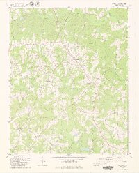
1979 Map of Castalia
USGS Topo · Published 1979About this map
The borderlands of Franklin Co and Nash Co in North Carolina are characterized by a network of rural hubs and watercourses as they appeared in the early 1970s. The town of Castalia serves as the central focal point, surrounded by a constellation of rural intersections including Lancaster Crossroads, Matthews Crossroads, and Mays Crossroads. These crossroads, typical of the Piedmont region's settlement patterns, provided essential social anchors for farming families through landmarks like Cedar Rock Ch and Bethlehem Ch. The landscape is deeply etched by a complex drainage system, where Back Swamp and Peachtree Branch feed into larger arteries like Little Peachtree Creek. In the south, Boddies Millpond indicates historical water-powered industry along Stony Cr, while the scattered presence of numerous cemeteries reflects the deep ancestral roots tied to this specific topography.
Find a feature on this map
26 named features on this map. Tap any name to fly to it.
Don’t see what you’re looking for? This feature index may not catch every label — zoom into the map to look around manually.
Map Details
Editions of this 1979 Castalia Map
2 editions found
Other maps of this area

1902 · Rocky Mount
USGS Topo · 1:62,500

1902 · Spring Hope
USGS Topo · 1:62,500

1904 · Rocky Mount
USGS Topo · 1:62,500

1904 · Springhope
USGS Topo · 1:62,500

1953 · Norfolk
USGS Topo · 1:250,000

1953 · Rocky Mount
USGS Topo · 1:250,000

1953 · Raleigh
USGS Topo · 1:250,000

1953 · Greensboro
USGS Topo · 1:250,000

1954 · Greensboro
USGS Topo · 1:250,000

1954 · Rocky Mount
USGS Topo · 1:250,000