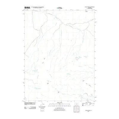
2010 Map of Castle Peak
USGS Topo · Published 2010About this map
Castle Peak and Pisgah Mountain anchor this high-altitude landscape in Eagle County, defined by a complex network of drainage basins and irrigation infrastructure. The terrain transitions from the heights of Winter Ridge and Horse Mountain down to the meadows of Castle Park. Water management is central to this area, evidenced by the presence of Hurt Reservoir, GG Upper Reservoir, and the Leonard-Horn Ditch Number 1, which diverts water across the undulating topography. Local road networks like Catamount Creek Rd and Eby Creek Rd provide access through these mountain gaps, including Coberly Gap, serving as vital connectors for ranching or recreational transit in this part of the Rockies.
Find a feature on this map
32 named features on this map. Tap any name to fly to it.
Don’t see what you’re looking for? This feature index may not catch every label — zoom into the map to look around manually.
Map Details
Editions of this 2010 Castle Peak Map
This is the sole edition of this map. No revisions or reprints were ever made.
Other maps of this area

1957 · Leadville
USGS Topo · 1:250,000

1959 · Leadville
USGS Topo · 1:250,000

1960 · Leadville
USGS Topo · 1:250,000

1962 · Leadville
USGS Topo · 1:250,000

1962 · Gypsum
USGS Topo · 1:24,000

1962 · Wolcott
USGS Topo · 1:24,000

1962 · Eagle
USGS Topo · 1:24,000

1964 · Leadville
USGS Topo · 1:250,000
1972 · Mc Coy
USGS Topo · 1:24,000

1972 · Blue Hill
USGS Topo · 1:24,000