1972 Map of Mc Coy
USGS Topo · Published 1975About this map
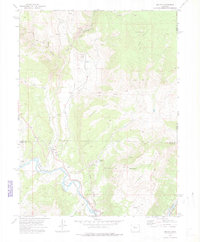
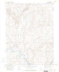
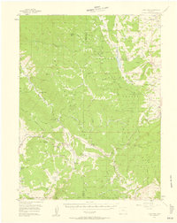
The Colorado River carves through this stretch of Colorado high country where the Denver and Rio Grande Western railroad follows the river's edge, serving the settlements of McCoy and Bond. This 1970s landscape is defined by its volcanic geology and water management, featuring a prominent Volcano, a large Crater, and the Congor Mesa. Regional ranching and agriculture are supported by the Elevated Mutual Ditch and Kayser Mutual Ditch, which transport water across the divide between Rock Creek and Egeria Creek. Local history is anchored at the McCoy Cem and the Grave near the river, while industry is noted through a Tipple, Cinder Pit, and various Prospects scattered across the slopes of Yarmony Mountain.
Find a feature on this map
34 named features on this map. Tap any name to fly to it.
Don’t see what you’re looking for? This feature index may not catch every label — zoom into the map to look around manually.
Map Details
Editions of this 1972 Mc Coy Map
3 editions found

Other maps of this area

1954 · Craig
USGS Topo · 1:250,000
1956 · Gore Pass
USGS Topo · 1:62,500

1957 · Craig
USGS Topo · 1:250,000

1957 · Leadville
USGS Topo · 1:250,000

1958 · Craig
USGS Topo · 1:250,000

1959 · Leadville
USGS Topo · 1:250,000

1960 · Leadville
USGS Topo · 1:250,000

1960 · Craig
USGS Topo · 1:250,000

1962 · Leadville
USGS Topo · 1:250,000

1962 · Craig
USGS Topo · 1:250,000