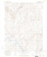
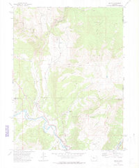
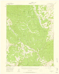
1972 Map of Mc Coy
USGS Topo · Published 1975About this map
McCoy and Bond serve as the primary focal points of this 1970s survey, situated along the winding course of the Colorado River and the tracks of the Denver and Rio Grande Western railroad. The landscape is defined by massive topographic features like Yarmony Mountain and Congor Mesa, where the interaction of water and altitude is evident in the complex irrigation systems of the Elevated Ditch and Kayser Mutual Ditch. Local history is anchored at the McCoy Cem and several scattered industrial sites, including a Tipple Cinder Pit and various locations marked as Prospect. These small-scale excavations, alongside the Copper Spur landmark, reveal a history of resource extraction and mountain ranching within the rugged Eagle and Routt County borderlands.
Find a feature on this map
27 named features on this map. Tap any name to fly to it.
Don’t see what you’re looking for? This feature index may not catch every label — zoom into the map to look around manually.
Map Details
Editions of this 1972 Mc Coy Map
3 editions found

Other maps of this area

1954 · Craig
USGS Topo · 1:250,000
1956 · Gore Pass
USGS Topo · 1:62,500

1957 · Craig
USGS Topo · 1:250,000

1957 · Leadville
USGS Topo · 1:250,000

1958 · Craig
USGS Topo · 1:250,000

1959 · Leadville
USGS Topo · 1:250,000

1960 · Leadville
USGS Topo · 1:250,000

1960 · Craig
USGS Topo · 1:250,000

1962 · Leadville
USGS Topo · 1:250,000

1962 · Craig
USGS Topo · 1:250,000