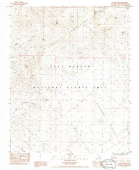
1984 Map of Castle Peaks
USGS Topo · Published 1984About this map
The settlement of Barnwell serves as a focal point in this high-desert landscape, positioned near the intersection of the New York Mountains and the northern reaches of Lanfair Valley. This 1980s-era documentation highlights the transition from active extraction to a protected landscape within the East Mojave National Scenic Area. Evidence of earlier industry is clear through the Old Railroad Grade and numerous unnamed extraction points labeled as Prospect Shaft, Shafts, and a Borrow Pit. Water remains a critical and named resource in this arid environment, with several reliable points such as Willow Spring, Bathtub Spring, and Malpais Springs scattered across the terrain. The northern boundary is dominated by the dramatic topography of Castle Peaks, while the lowlands are defined by drainage systems like Willow Wash.
Find a feature on this map
20 named features on this map. Tap any name to fly to it.
Don’t see what you’re looking for? This feature index may not catch every label — zoom into the map to look around manually.
Map Details
Editions of this 1984 Castle Peaks Map
This is the sole edition of this map. No revisions or reprints were ever made.
Other maps of this area

1910 · Ivanpah
USGS Topo · 1:250,000

1912 · Ivanpah
USGS Topo · 1:250,000

1942 · Ivanpah
USGS Topo · 1:250,000

1947 · Kingman
USGS Topo · 1:250,000

1948 · Kingman
USGS Topo · 1:250,000

1954 · Kingman
USGS Topo · 1:250,000

1955 · Kingman
USGS Topo · 1:250,000

1955 · Mid Hills
USGS Topo · 1:62,500
1956 · Lanfair Valley
USGS Topo · 1:62,500

1956 · Ivanpah
USGS Topo · 1:62,500