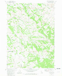
1981 Map of Castle Rock
USGS Topo · Published 1981About this map
Caribou National Forest dominates this section of the Idaho backcountry, where the high-altitude terrain of the Fall Creek Basin meets the county line. The landscape is defined by an intricate network of drainage systems, including Peterson Creek, Beaver Creek, and Monument Creek, many of which originate from numerous unnamed and named Springs like Willow Springs. These water sources were vital for the seasonal livestock operations indicated by the Fall Creek Cow Camp in the northeastern corner. Transportation through this complex topography was limited to primitive routes like the Skyline Road and the Boundary Trail, which trace the ridges and divides. The prominent landmark of Castle Rock stands near the boundary between Bonneville and Bingham counties, serving as a natural navigational beacon for those traversing the high country.
Find a feature on this map
28 named features on this map. Tap any name to fly to it.
Don’t see what you’re looking for? This feature index may not catch every label — zoom into the map to look around manually.
Map Details
Editions of this 1981 Castle Rock Map
This is the sole edition of this map. No revisions or reprints were ever made.
Other maps of this area

1917 · Cranes Flat
USGS Topo · 1:62,500

1924 · Hell Creek
USGS Topo · 1:62,500

1926 · Hell Creek
USGS Topo · 1:62,500

1932 · Irwin
USGS Topo · 1:96,000

1935 · Irwin
USGS Topo · 1:125,000

1955 · Driggs
USGS Topo · 1:250,000

1958 · Driggs
USGS Topo · 1:250,000

1962 · Driggs
USGS Topo · 1:250,000

1966 · Conant Valley
USGS Topo · 1:24,000
1966 · Herman
USGS Topo · 1:24,000