1983 Map of Castle Rock
USGS Topo · Published 1983About this map
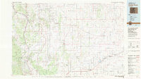
Castle Rock stands as a central hub in this early 1980s landscape, where the Front Range meets the eastern plains of Colorado. The map documents the intricate drainage systems of the Palmer Divide, where the headwaters of Cherry Creek and Kiowa Creek flow north while Big Sandy Creek begins its journey to the southeast. Major transportation corridors are well-defined, including the Atwison Topeka and Santa Fe and the Denver and Rio Grande Western railroads, which parallel the foothills through settlements like Larkspur and Palmer Lake. To the south, the sprawling grounds of the United States Air Force Academy sit near the base of the Pike National Forest. This survey captures the transition from the dense woodlands of the Black Forest to the open ranching country around Simla and Calhan before significant suburban expansion redefined the region.
Find a feature on this map
68 named features on this map. Tap any name to fly to it.
Don’t see what you’re looking for? This feature index may not catch every label — zoom into the map to look around manually.
Map Details
Editions of this 1983 Castle Rock Map
This is the sole edition of this map. No revisions or reprints were ever made.
Other maps of this area

1889 · Sanborn
USGS Topo · 1:125,000

1890 · East Denver
USGS Topo · 1:125,000

1891 · Sanborn
USGS Topo · 1:125,000

1891 · Limon
USGS Topo · 1:125,000

1892 · Limon
USGS Topo · 1:125,000

1893 · Sanborn
USGS Topo · 1:125,000

1893 · Big Springs
USGS Topo · 1:125,000

1893 · Platte Canyon
USGS Topo · 1:125,000

1893 · Colorado Springs
USGS Topo · 1:125,000

1894 · Pikes Peak
USGS Topo · 1:125,000