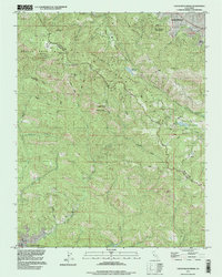
1997 Map of Castle Rock Ridge
USGS Topo · Published 1999About this map
Santa Cruz County Mountains define the topography of this region, where the county line separates Saratoga and Monte Sereno from the wooded drainage basins to the south. The 1990s landscape is anchored by Castle Rock State Park, featuring landmarks like Summit Rock, Goat Rock, and Castle Rock Falls. The survey provides a clear view of the complex hydrology of the San Andreas Rift Zone Park, including the Lake Ranch Reservoir and the headwaters of Saratoga Creek. Cultural footprints range from the historic Villa Montalvo and its arboretum to the isolated Uncle Billys Cabin near Mount Bielawski. Along the eastern edge, the elevation drops toward the Lexington Res, passing the Lakeside Sch and small water bodies like Lake Cozzens. The winding route of Skyline Boulevard serves as the primary spine across the ridge, connecting these geological landmarks and conservation areas.
Find a feature on this map
56 named features on this map. Tap any name to fly to it.
Don’t see what you’re looking for? This feature index may not catch every label — zoom into the map to look around manually.
Map Details
Editions of this 1997 Castle Rock Ridge Map
This is the sole edition of this map. No revisions or reprints were ever made.
Other maps of this area

1889 · San Jose
USGS Topo · 1:62,500

1897 · San Jose
USGS Topo · 1:62,500

1897 · Palo Alto
USGS Topo · 1:62,500

1899 · San Jose
USGS Topo · 1:62,500

1899 · Palo Alto
USGS Topo · 1:62,500

1902 · Santa Cruz
USGS Topo · 1:125,000

1916 · New Almaden
USGS Topo · 1:48,000

1919 · New Almaden
USGS Topo · 1:62,500

1940 · Los Gatos
USGS Topo · 1:62,500

1941 · Palo Alto
USGS Topo · 1:62,500