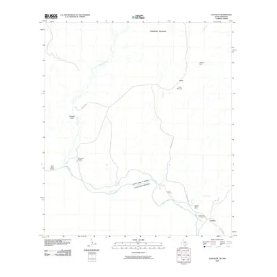
2010 Map of Castolon
USGS Topo · Published 2010About this map
The Rio Grande forms a sweeping international boundary through this high-desert region, where the Castolon Historic District preserves the remnants of an early 20th-century farming and trading outpost. This 2010 topographic record captures a landscape defined by ephemeral washes and rugged elevations like the Rattlesnake Mountains and Pena Mountain. Small, isolated settlements like Terlingua Abaja and Lunas are connected by narrow desert routes including the Castolon River Rd. Near the river's edge, the Cottonwood Campground and Santa Elena Canyon Lookout provide orientation for those navigating the dramatic transition into Santa Elena Canyon. The presence of the Coyote Cemetery and the confluence of Terlingua Creek and the Rio Grande highlight the area's long-standing human connection to these scarce water sources in Brewster County.
Find a feature on this map
20 named features on this map. Tap any name to fly to it.
Don’t see what you’re looking for? This feature index may not catch every label — zoom into the map to look around manually.
Map Details
Editions of this 2010 Castolon Map
This is the sole edition of this map. No revisions or reprints were ever made.
Other maps of this area

1903 · Chisos Mountains
USGS Topo · 1:125,000

1903 · Terlingua
USGS Topo · 1:125,000

1904 · Terlingua
USGS Topo · 1:125,000

1905 · Chisos Mountains
USGS Topo · 1:125,000

1959 · Emory Peak
USGS Topo · 1:250,000

1965 · Emory Peak
USGS Topo · 1:250,000

1971 · Terlingua
USGS Topo · 1:24,000

1971 · Cerro Castellan
USGS Topo · 1:24,000

1971 · Amarilla Mountain
USGS Topo · 1:24,000
1971 · Tule Mountain
USGS Topo · 1:24,000