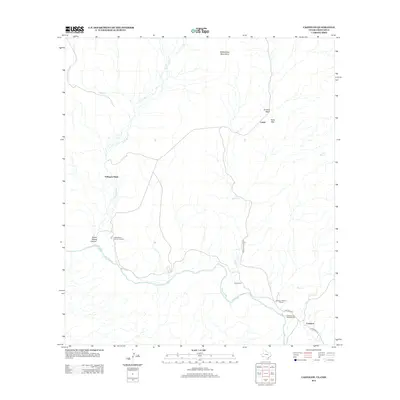
2012 Map of Castolon
USGS Topo · Published 2012About this map
The Rio Grande snakes along the southern border of this desert landscape, defining the international boundary and the dramatic entrance to Santa Elena Canyon. Near the river's bend, the Castolon Historic District and Cottonwood Campground serve as focal points for human activity in this arid environment. The map details a network of seasonal drainages, such as Terlingua Cr and Alamo Cr, which cut through the terrain toward the river. Historically significant sites like Terlingua Abaja and the Coyote Cem are positioned along these watercourses, reflecting the area's long history of ranching and borderland settlement. To the north, the elevation rises toward the Rattlesnake Mountains and Peña Mtn, while the Santa Elena Canyon Lookout offers a vantage point over the deep limestone gorge that dominates the southwestern corner of the quadrangle.
Find a feature on this map
20 named features on this map. Tap any name to fly to it.
Don’t see what you’re looking for? This feature index may not catch every label — zoom into the map to look around manually.
Map Details
Editions of this 2012 Castolon Map
This is the sole edition of this map. No revisions or reprints were ever made.
Other maps of this area

1903 · Chisos Mountains
USGS Topo · 1:125,000

1903 · Terlingua
USGS Topo · 1:125,000

1904 · Terlingua
USGS Topo · 1:125,000

1905 · Chisos Mountains
USGS Topo · 1:125,000

1959 · Emory Peak
USGS Topo · 1:250,000

1965 · Emory Peak
USGS Topo · 1:250,000

1971 · Terlingua
USGS Topo · 1:24,000

1971 · Cerro Castellan
USGS Topo · 1:24,000

1971 · Amarilla Mountain
USGS Topo · 1:24,000
1971 · Tule Mountain
USGS Topo · 1:24,000