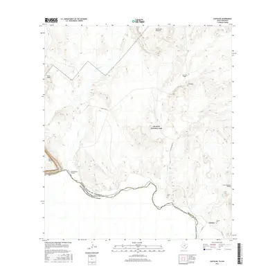
2016 Map of Castolon
USGS Topo · Published 2016About this map
The Rio Grande serves as the international boundary within Big Bend National Park, carving a dramatic course between the United States and Mexico. This survey captures the Chihuahuan Desert landscape where Terlingua Creek meets the river at the mouth of Santa Elena Canyon. The settlement of Castolon sits on the north bank, anchored by its proximity to the Rio Grande and historical river crossings. Notable landmarks include the prominent Mesa de Anguila to the west and the heights of Peña Mountain to the east. For genealogists and local historians, the map identifies the Castolon Cemetery and Coyote Cemetery, offering specific coordinates for these heritage sites in a region defined by its isolation and topographical features like the Cerro Castellan Window.
Find a feature on this map
24 named features on this map. Tap any name to fly to it.
Don’t see what you’re looking for? This feature index may not catch every label — zoom into the map to look around manually.
Map Details
Editions of this 2016 Castolon Map
This is the sole edition of this map. No revisions or reprints were ever made.
Other maps of this area

1903 · Chisos Mountains
USGS Topo · 1:125,000

1903 · Terlingua
USGS Topo · 1:125,000

1904 · Terlingua
USGS Topo · 1:125,000

1905 · Chisos Mountains
USGS Topo · 1:125,000

1959 · Emory Peak
USGS Topo · 1:250,000

1965 · Emory Peak
USGS Topo · 1:250,000

1971 · Terlingua
USGS Topo · 1:24,000

1971 · Cerro Castellan
USGS Topo · 1:24,000

1971 · Amarilla Mountain
USGS Topo · 1:24,000
1971 · Tule Mountain
USGS Topo · 1:24,000