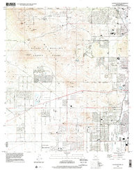
1996 Map of Cat Mountain
USGS Topo · Published 2002About this map
Tucson Mountain County Park and the western reaches of Tucson anchor this desert landscape, where the urban edge meets distinctive mountain peaks. The geography is defined by prominent volcanic and geological formations like Tumamoc Hill, Cat Mountain, and the rugged approach through Gates Pass. To the south and east, the Pascua Yaqui Indian Reservation and the Tohono O'odham Reservation (San Xavier District) show the complex jurisdictional boundaries of the Sonoran Desert.
Find a feature on this map
52 named features on this map. Tap any name to fly to it.
Don’t see what you’re looking for? This feature index may not catch every label — zoom into the map to look around manually.
Map Details
Editions of this 1996 Cat Mountain Map
This is the sole edition of this map. No revisions or reprints were ever made.
Other maps of this area

1904 · Tucson
USGS Topo · 1:125,000

1905 · Tucson
USGS Topo · 1:125,000

1925 · San Xavier
USGS Topo · 1:62,500

1934 · Tucson Mountains
USGS Topo · 1:125,000

1943 · San Xavier Mission
USGS Topo · 1:62,500

1947 · Cortaro
USGS Topo · 1:62,500

1948 · Tucson
USGS Topo · 1:62,500

1956 · Tucson
USGS Topo · 1:250,000

1957 · San Xavier Mission
USGS Topo · 1:62,500

1957 · Tucson
USGS Topo · 1:24,000