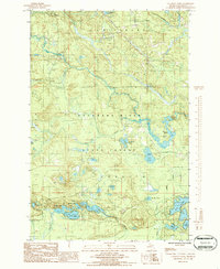
1986 Map of Cataract Basin
USGS Topo · Published 1986About this map
Escanaba River State Forest dominates this Marquette County landscape, where the Middle Branch Escanaba River and the main Escanaba River converge. The topography is defined by the namesake Cataract Basin and a dense network of water bodies, including Shag Lake, Horseshoe Lake, and Mud Lake. This mid-1980s provisional survey shows a wilderness region managed for timber and recreation, indicated by the presence of a Campground, several Boat Ramps, and the Chipmunk Airstrip. Small-scale industry is represented by a Gravel Pit near O'Neal Creek and a Gaging Station on the river. The map also captures the local recreation culture of the Upper Peninsula with a Trailer Park near the riverbanks and numerous interconnected lakes like Bass Lake and Pike Lake that draw anglers and outdoorsmen to the Richmond and Tilden townships.
Find a feature on this map
37 named features on this map. Tap any name to fly to it.
Don’t see what you’re looking for? This feature index may not catch every label — zoom into the map to look around manually.
Map Details
Editions of this 1986 Cataract Basin Map
This is the sole edition of this map. No revisions or reprints were ever made.
Other maps of this area

1932 · Helena NW
USGS Topo · 1:31,680

1932 · Harvey NW
USGS Topo · 1:31,680

1932 · Harvey SW
USGS Topo · 1:31,680

1951 · Helena NW
USGS Topo · 1:31,680

1952 · Sands
USGS Topo · 1:24,000

1952 · Ishpeming
USGS Topo · 1:62,500

1952 · Ishpeming
USGS Topo · 1:24,000

1952 · Gwinn
USGS Topo · 1:62,500

1952 · Palmer
USGS Topo · 1:24,000

1952 · Gwinn
USGS Topo · 1:24,000