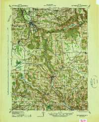
1938 Map of Cattaraugus
USGS Topo · Published 1938About this map
The Cattaraugus Indian Reservation and the winding course of Cattaraugus Creek anchor this late 1930s survey of western New York. This era highlights a landscape of dispersed agricultural hamlets and a dense network of one-room schoolhouses, including Poverty Hill School, Milk School, and the Brooklyn School. The Erie railroad corridor serves as the primary industrial spine, connecting the major hubs of Gowanda and Cattaraugus.
Find a feature on this map
81 named features on this map. Tap any name to fly to it.
Don’t see what you’re looking for? This feature index may not catch every label — zoom into the map to look around manually.
Map Details
Editions of this 1938 Cattaraugus Map
This is the sole edition of this map. No revisions or reprints were ever made.
Other maps of this area
1899 · Silver Creek
USGS Topo · 1:62,500
1900 · Cherry Creek
USGS Topo · 1:62,500
1900 · Salamanca
USGS Topo · 1:62,500
1905 · Jamestown
USGS Topo · 1:62,500
1905 · Eden
USGS Topo · 1:62,500
1907 · Eden
USGS Topo · 1:62,500
1922 · Randolph
USGS Topo · 1:62,500
1923 · Randolph
USGS Topo · 1:62,500
1923 · Cattaraugus
USGS Topo · 1:62,500
1924 · Ellicottville
USGS Topo · 1:62,500