
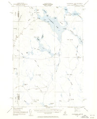
1954 Map of Caucomgomoc Lake
USGS Topo · Published 1955About this map
Caucomgomoc Lake dominates this northern Maine landscape, a region defined by its complex network of waterways and the infrastructure of early 20th-century logging. The presence of Caucomgomoc Dam, Loon Lake Dam, and Caribou Dam reveals the heavy management of water levels to support the timber industry, allowing logs to be driven through Ciss Stream and Loon Stream.
Find a feature on this map
58 named features on this map. Tap any name to fly to it.
Don’t see what you’re looking for? This feature index may not catch every label — zoom into the map to look around manually.
Map Details
Editions of this 1954 Caucomgomoc Lake Map
2 editions found
Other maps of this area

1954 · Seboomook Lake
USGS Topo · 1:62,500

1954 · Chesuncook
USGS Topo · 1:62,500

1954 · North East Carry
USGS Topo · 1:62,500

1954 · Baker Lake
USGS Topo · 1:62,500

1954 · Churchill Lake
USGS Topo · 1:62,500

1954 · Allagash Lake
USGS Topo · 1:62,500

1954 · St. John Pond
USGS Topo · 1:62,500

1954 · Grant Farm
USGS Topo · 1:62,500

1954 · Presque Isle
USGS Topo · 1:250,000

1954 · Millinocket
USGS Topo · 1:250,000