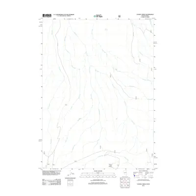
2012 Map of Caudle Creek
USGS Topo · Published 2012About this map
Caudle Creek and its many tributaries define this high-desert landscape in Elko County, where the topography is shaped by a dense network of intermittent and perennial watercourses. The drainage patterns of Pole Creek, Sheep Creek, and Raker Creek flow through open terrain, eventually meeting the larger Canyon Creek corridor at the southern edge. This 2012 survey illustrates a landscape primarily managed for ranching and resource access, evidenced by the presence of Coyote Spring and Black Spring, as well as the distinctive formation known as Canyon Creek Pockets.
Find a feature on this map
17 named features on this map. Tap any name to fly to it.
Don’t see what you’re looking for? This feature index may not catch every label — zoom into the map to look around manually.
Map Details
Editions of this 2012 Caudle Creek Map
This is the sole edition of this map. No revisions or reprints were ever made.
Other maps of this area

1943 · Jarbidge
USGS Topo · 1:62,500

1945 · Jarbidge
USGS Topo · 1:62,500

1955 · Twin Falls
USGS Topo · 1:250,000

1955 · Wells
USGS Topo · 1:250,000

1957 · Elk Mountain
USGS Topo · 1:62,500

1958 · Wells
USGS Topo · 1:250,000

1958 · Twin Falls
USGS Topo · 1:250,000

1961 · Wells
USGS Topo · 1:250,000
1979 · Three Creek
USGS Topo · 1:24,000
1979 · Murphy Hot Springs
USGS Topo · 1:24,000