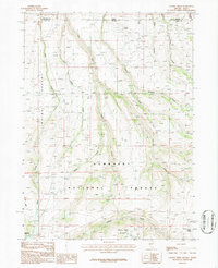
1986 Map of Caudle Creek
USGS Topo · Published 1987About this map
The Humboldt National Forest covers the southern expanse of this high-altitude landscape, where the Idaho-Nevada border meets the divide between Owyhee and Elko counties. This 1980s provisional survey documents a transition from the drainage systems of Caudle Creek and Sheep Creek into the arid northern territory of the Inside Desert. The presence of the Pole Creek Ranger Sta and various water sources like Coyote Spring and Black Spring highlight the infrastructure required for managing this remote rangeland. A complex network of drainage basins is visible, with Cherry Creek and Hays Canyon Creek carving deep paths through the terrain. The map provides clear evidence of the livestock-driven economy of the era, marked by numerous small springs and the junction of significant backcountry trails and forest boundaries.
Find a feature on this map
20 named features on this map. Tap any name to fly to it.
Don’t see what you’re looking for? This feature index may not catch every label — zoom into the map to look around manually.
Map Details
Editions of this 1986 Caudle Creek Map
This is the sole edition of this map. No revisions or reprints were ever made.
Other maps of this area

1943 · Jarbidge
USGS Topo · 1:62,500

1945 · Jarbidge
USGS Topo · 1:62,500

1955 · Twin Falls
USGS Topo · 1:250,000

1955 · Wells
USGS Topo · 1:250,000

1957 · Elk Mountain
USGS Topo · 1:62,500

1958 · Wells
USGS Topo · 1:250,000

1958 · Twin Falls
USGS Topo · 1:250,000

1961 · Wells
USGS Topo · 1:250,000
1979 · Three Creek
USGS Topo · 1:24,000
1979 · Murphy Hot Springs
USGS Topo · 1:24,000