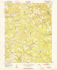
1951 Map of Cauthornville
USGS Topo · Published 1951About this map
The rolling interior of the Middle Peninsula is defined by the convergence of King and Queen, Essex, and Caroline counties in this early 1950s survey. The landscape is dominated by a complex network of creeks and swamps, including King and Queen Swamp and the headwaters of Hoskins Creek, where milling operations like Garnett Mill and Motley Mill Pond once anchored the local economy. Small crossroads communities and post offices are scattered throughout, providing a clear look at the rural social structure of the era through institutional landmarks like the King and Queen Training Sch, Battery Sch, and Harmony Sch. Several prominent houses of worship, such as Indian Neck Ch and Mt Olive Ch, serve as focal points for the surrounding rural populations. The map also records the location of a local Battery and Lookout Tower, alongside numerous family burial grounds marked simply as Cemeteries.
Find a feature on this map
34 named features on this map. Tap any name to fly to it.
Don’t see what you’re looking for? This feature index may not catch every label — zoom into the map to look around manually.
Map Details
Editions of this 1951 Cauthornville Map
This is the sole edition of this map. No revisions or reprints were ever made.
Other maps of this area

1889 · Fredericksburg
USGS Topo · 1:125,000

1892 · Fredericksburg
USGS Topo · 1:125,000

1892 · Montross
USGS Topo · 1:62,500

1894 · Fredericksburg
USGS Topo · 1:125,000

1895 · Nomini
USGS Topo · 1:125,000

1895 · Montross
USGS Topo · 1:62,500

1898 · Nomini
USGS Topo · 1:125,000

1918 · Tappahannock
USGS Topo · 1:62,500

1918 · Aylett
USGS Topo · 1:62,500

1919 · Tappahannock
USGS Topo · 1:62,500