
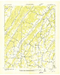
1936 Map of Cave Creek
USGS Topo · Published 1936About this map
Tennessee River frontage dominates this mid-1930s landscape along the border of Roane and Loudon Counties. The river's winding path is defined by significant features like Bacon Shoals and a series of river islands, including Seven Islands, Wilson Island, and Bogart Island. The surrounding terrain is heavily ridged, with Chestnut Ridge and Dug Ridge running parallel to the water, shaping the location of local farm-to-market routes and small upland settlements like Grays Hill.
Find a feature on this map
59 named features on this map. Tap any name to fly to it.
Don’t see what you’re looking for? This feature index may not catch every label — zoom into the map to look around manually.
Map Details
Editions of this 1936 Cave Creek Map
This is the sole edition of this map. No revisions or reprints were ever made.
Other maps of this area

1887 · Kingston
USGS Topo · 1:125,000

1891 · Kingston
USGS Topo · 1:125,000

1893 · Kingston
USGS Topo · 1:125,000

1895 · Loudon
USGS Topo · 1:125,000

1935 · Lenoir City
USGS Topo · 1:24,000

1935 · Elverton
USGS Topo · 1:24,000

1935 · Bethel Valley
USGS Topo · 1:24,000

1935 · Harriman
USGS Topo · 1:24,000

1935 · Philadelphia
USGS Topo · 1:24,000
1936 · Pattie Gap
USGS Topo · 1:24,000