1935 Map of Philadelphia
USGS Topo · Published 1935About this map
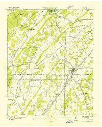
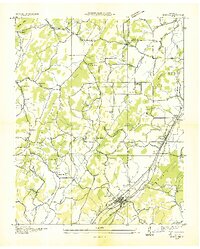
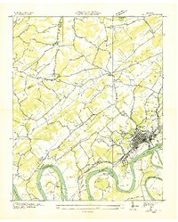
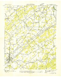
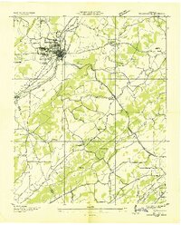
Philadelphia serves as the primary hub of this 1935 study, situated along the Southern railroad line near the boundary of Loudon and Monroe Counties. The landscape is defined by a series of parallel ridges, including Snow Ridge, Matlock Ridge, and Black Oak Ridge, which channel the flow of Sweetwater Creek and Pond Creek toward the Tennessee River. This era shows a rural society organized around small schoolhouses and country churches, such as the combined Stockton Valley Church and Snows School and the isolated Sunnyside School.
Find a feature on this map
56 named features on this map. Tap any name to fly to it.
Don’t see what you’re looking for? This feature index may not catch every label — zoom into the map to look around manually.
Map Details
Editions of this 1935 Philadelphia Map
This is the sole edition of this map. No revisions or reprints were ever made.
Other maps of this area

1887 · Kingston
USGS Topo · 1:125,000

1891 · Kingston
USGS Topo · 1:125,000

1893 · Kingston
USGS Topo · 1:125,000

1895 · Loudon
USGS Topo · 1:125,000
1935 · Niota
USGS Topo · 1:24,000
1935 · Lenoir City
USGS Topo · 1:24,000

1936 · Cave Creek
USGS Topo · 1:24,000
1936 · Madisonville
USGS Topo · 1:24,000
1936 · Sweetwater
USGS Topo · 1:24,000

1936 · Pattie Gap
USGS Topo · 1:24,000