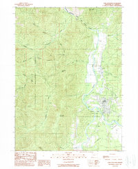
1989 Map of Cave Junction
USGS Topo · Published 1989About this map
Cave Junction and the historic settlement of Kerby anchor the eastern valley of the Illinois River in the late 1980s. This survey illustrates the transition from the forested heights of the Siskiyou National Forest to the managed landscapes of Illinois River State Park. The terrain is marked by numerous named gulches and creeks, including Josephine Creek and Fiddler Gulch, which feed into the Illinois National Wild and Scenic River. Local landmarks like Eight Dollar Mountain and Woodcock Mountain dominate the horizon, while smaller sites such as Laurel Cem and Pomeroy Dam provide specific points of interest for genealogists and local historians. The presence of a Guard Station and several mountain passes, such as Tennessee Pass, reflects the era's focus on forest management and accessibility within the rugged Southern Oregon landscape.
Find a feature on this map
33 named features on this map. Tap any name to fly to it.
Don’t see what you’re looking for? This feature index may not catch every label — zoom into the map to look around manually.
Map Details
Editions of this 1989 Cave Junction Map
This is the sole edition of this map. No revisions or reprints were ever made.
Other maps of this area

1917 · Kerby
USGS Topo · 1:125,000

1918 · Kerby
USGS Topo · 1:125,000

1945 · Kerby
USGS Topo · 1:125,000

1954 · Cave Junction
USGS Topo · 1:62,500

1954 · Selma
USGS Topo · 1:62,500

1954 · Chetco Peak
USGS Topo · 1:62,500

1954 · Pearsoll Peak
USGS Topo · 1:62,500

1955 · Medford
USGS Topo · 1:250,000

1957 · Medford
USGS Topo · 1:250,000

1958 · Medford
USGS Topo · 1:250,000