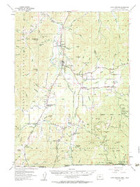
1954 Map of Cave Junction
USGS Topo · Published 1963About this map
Cave Junction and the surrounding Illinois Valley landscape are captured here during a mid-century period of transition, where timber and mining legacies meet emerging modern infrastructure. The Redwood Highway serves as the primary artery, connecting settlements like Kerby and O'Brien while passing a Drive-in Theater and a Landing Strip near the town center. The map documents the enduring footprint of the region's mining history, notably at the Esterly Mine and the historic Waldo (Site).
Find a feature on this map
99 named features on this map. Tap any name to fly to it.
Don’t see what you’re looking for? This feature index may not catch every label — zoom into the map to look around manually.
Map Details
Editions of this 1954 Cave Junction Map
3 editions found

Other maps of this area

1908 · Grants Pass
USGS Topo · 1:125,000

1914 · Seiad
USGS Topo · 1:125,000

1917 · Kerby
USGS Topo · 1:125,000

1918 · Kerby
USGS Topo · 1:125,000

1922 · Preston Peak
USGS Topo · 1:125,000

1922 · Seiad
USGS Topo · 1:125,000

1945 · Kerby
USGS Topo · 1:125,000

1945 · Gasquet
USGS Topo · 1:62,500

1948 · Weed
USGS Topo · 1:250,000

1950 · Weed
USGS Topo · 1:250,000