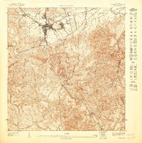
1947 Map of Cayey NE
USGS Topo · Published 1947About this map
The town of Cayey serves as the focal point of this mid-century topographic survey, situated at a vital junction where the historic Carretera Central meets the surrounding mountain passes. The landscape is dominated by the sprawling U.S. Military Reservation and the adjacent Cayey Military Reservation, which occupy the high ground overlooking the settlement. This mapping effort, based on 1943 topography, reveals a complex network of steep ridges and deep valleys, including the heights of Monte El Gato and El Torito.
Find a feature on this map
13 named features on this map. Tap any name to fly to it.
Don’t see what you’re looking for? This feature index may not catch every label — zoom into the map to look around manually.
Map Details
Editions of this 1947 Cayey NE Map
This is the sole edition of this map. No revisions or reprints were ever made.
Other maps of this area

1946 · Patillas
USGS Topo · 1:30,000

1946 · Cayey
USGS Topo · 1:30,000

1946 · Comerio
USGS Topo · 1:30,000

1946 · Caguas
USGS Topo · 1:30,000

1947 · Cayey NO
USGS Topo · 1:10,000

1947 · Patillas SO
USGS Topo · 1:10,000

1947 · Cayey SO
USGS Topo · 1:10,000
1947 · Comerio SE
USGS Topo · 1:10,000
1947 · Comerio SO
USGS Topo · 1:10,000
1947 · Cayey SE
USGS Topo · 1:10,000
Featured Places
- Cayey
- Alturas de Cantera, Cayey
- Sector Rústico Rivera, Cayey
- Sector Ramón Malavé, Cayey
- Sector Los Paganes, Cayey