
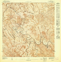
1947 Map of Cayey NO
USGS Topo · Published 1947About this map
The Cordillera Central dominates this 1943 topographic survey, illustrating the complex ridgelines and deep valleys where the municipal boundaries of Aibonito, Cayey, Coamo, and Salinas converge. The landscape is defined by significant elevations such as Cerro Planada, Peña Dominga, and Cerro Avispa, which rise above the headwaters of the Rio Lapa and Rio Cuyon. Settlement patterns in this era are concentrated in areas like Las Tetas and Proyecto Vazquez, with the map detailing the winding road networks and small structures that supported local agricultural life before mid-century modernization. The meticulous contouring reveals the steep descent from high peaks like La Piedra toward the southern coastal plains, providing a clear view of the drainage systems including the Maton and various unnamed quebradas that shaped the region's hydrology and land use during the 1940s.
Find a feature on this map
17 named features on this map. Tap any name to fly to it.
Don’t see what you’re looking for? This feature index may not catch every label — zoom into the map to look around manually.
Map Details
Editions of this 1947 Cayey NO Map
This is the sole edition of this map. No revisions or reprints were ever made.
Other maps of this area

1946 · Coamo
USGS Topo · 1:30,000

1946 · Barranquitas
USGS Topo · 1:30,000

1946 · Cayey
USGS Topo · 1:30,000

1946 · Comerio
USGS Topo · 1:30,000

1947 · Cayey SO
USGS Topo · 1:10,000
1947 · Cayey NE
USGS Topo · 1:10,000
1947 · Comerio SE
USGS Topo · 1:10,000
1947 · Barranquitas SE
USGS Topo · 1:10,000
1947 · Coamo NE
USGS Topo · 1:10,000
1947 · Comerio SO
USGS Topo · 1:10,000