
1937 Map of Cayucos
USGS Topo · Published 1937About this map
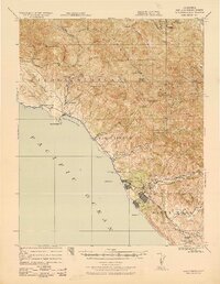
The central California coast around Estero Bay is documented here during the late 1930s, showing a landscape defined by its maritime geography and early petroleum infrastructure. Significant industrial development is visible at the Standard Oil Co Estero Bay Tankage and Loading Station just north of Morro Beach. The coastal settlements of Cayucos, Morro Bay, and Baywood Park are clearly established along the shoreline, connected by a network of primary and secondary roads.
Find a feature on this map
32 named features on this map. Tap any name to fly to it.
Don’t see what you’re looking for? This feature index may not catch every label — zoom into the map to look around manually.
Map Details
Editions of this 1937 Cayucos Map
This is the sole edition of this map. No revisions or reprints were ever made.
Other maps of this area

1897 · Port Harford
USGS Topo · 1:62,500

1897 · San Luis Obispo
USGS Topo · 1:62,500

1897 · Cayucos
USGS Topo · 1:62,500

1897 · Arroyo Grande
USGS Topo · 1:62,500

1900 · San Luis
USGS Topo · 1:125,000

1919 · Paso Robles
USGS Topo · 1:62,500

1919 · Adelaida
USGS Topo · 1:62,500

1919 · San Simeon
USGS Topo · 1:62,500

1932 · Adelaida
USGS Topo · 1:62,500
1937 · San Simeon
USGS Topo · 1:62,500