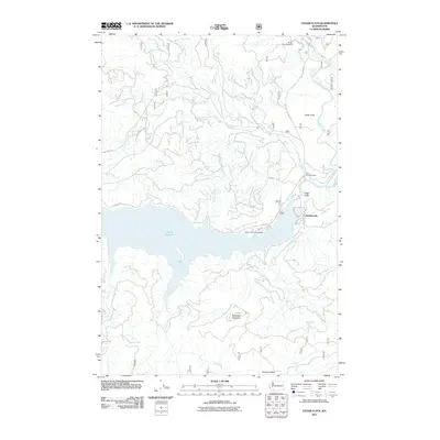
2011 Map of Cedar Flats
USGS Topo · Published 2011About this map
Swift Reservoir dominates the central landscape of this Skamania County quadrangle, where the Lewis River and Muddy River converge. The settlement of Northwoods sits along the northeastern shore, serving as a gateway to the high-elevation terrain surrounding McClellan Mountain. This 2011 survey captures the area's infrastructure for both timber and recreation, documented through a dense network of forest service roads like Nat For Dev Rd 25 and the development at Swift Forest Campground. To the south, Paradise Valley provides a distinct break in the topographic relief, while landmarks such as Eagle Cliffs and Cedar Flats define the northern drainages. The mapping of Pine Creek and its associated features, including Pine Creek Boulder, reflects the area's dynamic fluvial and geological history near the river confluence.
Find a feature on this map
24 named features on this map. Tap any name to fly to it.
Don’t see what you’re looking for? This feature index may not catch every label — zoom into the map to look around manually.
Map Details
Editions of this 2011 Cedar Flats Map
This is the sole edition of this map. No revisions or reprints were ever made.
Other maps of this area

1919 · Mount St Helens
USGS Topo · 1:125,000

1926 · Steamboat Mtn
USGS Topo · 1:125,000

1926 · Hood River
USGS Topo · 1:125,000

1929 · Hood River
USGS Topo · 1:125,000

1931 · Steamboat Mtn
USGS Topo · 1:125,000

1940 · Lookout Mtn
USGS Topo · 1:62,500

1948 · Vancouver
USGS Topo · 1:250,000

1950 · Vancouver
USGS Topo · 1:250,000

1950 · Vancouver
USGS Topo · 1:250,000

1950 · Yakima
USGS Topo · 1:250,000