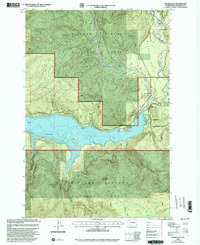
1998 Map of Cedar Flats
USGS Topo · Published 2003About this map
The Swift Reservoir dominates the lower-central terrain of this area within the Gifford Pinchot National Forest, where the reservoir waters are managed at Spillway Elev 1008. This survey reflects a landscape shaped by both natural water systems and forest management, featuring the Pine Creek Work Center Pine Creek Information Station and a Gaging Station near the Lewis River. The small settlement of Northwoods sits tucked near the shoreline, providing a human anchor in a region defined by steep timbered slopes rising toward McClellan Mountain and the prominent Eagle Cliffs. Recreation and education are evident through the Swift Forest Campground and the Cedar Flats Nature Trail, which provides access to the namesake Cedar Flats. The presence of a Gravel Pit near the Muddy River indicates the ongoing maintenance and utility required to manage these remote forest lands.
Find a feature on this map
20 named features on this map. Tap any name to fly to it.
Don’t see what you’re looking for? This feature index may not catch every label — zoom into the map to look around manually.
Map Details
Editions of this 1998 Cedar Flats Map
This is the sole edition of this map. No revisions or reprints were ever made.
Other maps of this area

1919 · Mount St Helens
USGS Topo · 1:125,000

1926 · Steamboat Mtn
USGS Topo · 1:125,000

1926 · Hood River
USGS Topo · 1:125,000

1929 · Hood River
USGS Topo · 1:125,000

1931 · Steamboat Mtn
USGS Topo · 1:125,000

1940 · Lookout Mtn
USGS Topo · 1:62,500

1948 · Vancouver
USGS Topo · 1:250,000

1950 · Vancouver
USGS Topo · 1:250,000

1950 · Vancouver
USGS Topo · 1:250,000

1950 · Yakima
USGS Topo · 1:250,000