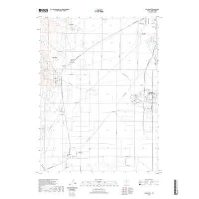
2020 Map of Cedar Fort
USGS Topo · Published 2020About this map
Cedar Fort and Fairfield anchor this portion of the Cedar Valley, where rural history meets modern expansion. The landscape is marked by a deep genealogical record, preserved through sites like the Cedar Fort Pioneer Cem and the Camp Floyd Cem. While the western slopes of Long Ridge and canyons such as Broadmouth Canyon maintain their natural character, the eastern reaches show the rapid suburban development of Eagle Mountain. This transition is clearly visible in the contrast between traditional water management features like the Cedar Fort Ditch and the modern residential grid branching off Pony Express Pkwy. Small-scale aviation also plays a role in the local geography, represented by the Cedar Valley Airport and the Glenmar Ranch Airport near the eastern boundary.
Find a feature on this map
81 named features on this map. Tap any name to fly to it.
Don’t see what you’re looking for? This feature index may not catch every label — zoom into the map to look around manually.
Map Details
Editions of this 2020 Cedar Fort Map
This is the sole edition of this map. No revisions or reprints were ever made.
Other maps of this area

1885 · Salt Lake
USGS Topo · 1:250,000

1885 · Tooele Valley
USGS Topo · 1:250,000

1915 · Fairfield
USGS Topo · 1:62,500

1917 · Fairfield
USGS Topo · 1:62,500

1947 · Fivemile Pass
USGS Topo · 1:62,500

1947 · Goshen Pass
USGS Topo · 1:24,000

1949 · Fivemile Pass
USGS Topo · 1:24,000

1949 · Goshen Pass
USGS Topo · 1:24,000
1950 · Soldiers Pass
USGS Topo · 1:24,000
1950 · West Mountain
USGS Topo · 1:62,500