
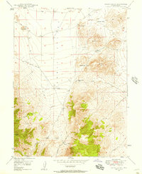
1947 Map of Fivemile Pass
USGS Topo · Published 1953About this map
Mining operations and historical transport corridors dominate this high-desert landscape spanning the boundary of Utah and Tooele counties. The southern reaches are defined by the intensive mineral extraction in the East Tintic Mountains, where a cluster of claims including the Lehi Tintic Mine, Hot Stuff Mine, and Tintic Paymaster Mine mark a significant era of Utah's industrial history. Evidence of shifting transit patterns is visible in the dismantled railroad grade and the Union Pacific line serving the settlement at Topliff.
Find a feature on this map
42 named features on this map. Tap any name to fly to it.
Don’t see what you’re looking for? This feature index may not catch every label — zoom into the map to look around manually.
Map Details
Editions of this 1947 Fivemile Pass Map
This is the sole edition of this map. No revisions or reprints were ever made.
Other maps of this area

1885 · Salt Lake
USGS Topo · 1:250,000

1885 · Manti
USGS Topo · 1:250,000

1885 · Sevier Desert
USGS Topo · 1:250,000

1885 · Tooele Valley
USGS Topo · 1:250,000

1895 · Manti
USGS Topo · 1:250,000

1915 · Fairfield
USGS Topo · 1:62,500

1917 · Fairfield
USGS Topo · 1:62,500

1918 · Stockton
USGS Topo · 1:62,500
1947 · Allens Ranch
USGS Topo · 1:24,000
1947 · Boulter Peak
USGS Topo · 1:24,000