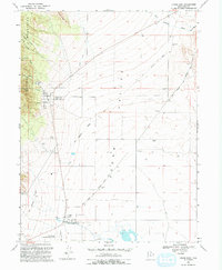
1993 Map of Cedar Fort
USGS Topo · Published 1993About this map
The Oquirrh Mountains rise sharply along the western edge of this valley landscape, where the historical imprint of frontier transportation is clearly visible. The Pony Express and Overland Stage Route cuts diagonally across the Cedar Valley, tracing a path through the high desert that once connected the eastern United States to California. This corridor is anchored by Fairfield, home to the Stage Coach Inn State Historical Site and Camp Floyd State Historical Site. These landmarks reflect the area's mid-19th-century role as a major military outpost and vital station on the overland trail.
Find a feature on this map
30 named features on this map. Tap any name to fly to it.
Don’t see what you’re looking for? This feature index may not catch every label — zoom into the map to look around manually.
Map Details
Editions of this 1993 Cedar Fort Map
This is the sole edition of this map. No revisions or reprints were ever made.
Other maps of this area

1885 · Salt Lake
USGS Topo · 1:250,000

1885 · Tooele Valley
USGS Topo · 1:250,000

1915 · Fairfield
USGS Topo · 1:62,500

1917 · Fairfield
USGS Topo · 1:62,500

1947 · Fivemile Pass
USGS Topo · 1:62,500

1947 · Goshen Pass
USGS Topo · 1:24,000

1949 · Fivemile Pass
USGS Topo · 1:24,000

1949 · Goshen Pass
USGS Topo · 1:24,000
1950 · Soldiers Pass
USGS Topo · 1:24,000
1950 · West Mountain
USGS Topo · 1:62,500