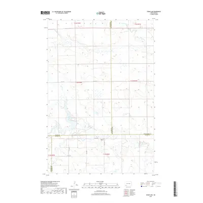
2018 Map of Cedar Lake
USGS Topo · Published 2018About this map
Cedar Lake sits at the heart of this North Dakota landscape, where the borders of Slope, Hettinger, Adams, and Bowman counties converge. The terrain is defined by the branching waters of Cedar Creek, fed by the N Cedar Cr and S Cedar Cr, alongside the winding path of Chanta Peta Creek in the northern reaches. This 2018 survey illustrates a sparsely populated agricultural region structured by the Public Land Survey System, with township lines like t133n r98w and t132n r98w organizing the vast open sections.
Find a feature on this map
21 named features on this map. Tap any name to fly to it.
Don’t see what you’re looking for? This feature index may not catch every label — zoom into the map to look around manually.
Map Details
Editions of this 2018 Cedar Lake Map
This is the sole edition of this map. No revisions or reprints were ever made.
Other maps of this area
1953 · Dickinson
USGS Topo · 1:250,000
1957 · Dickinson
USGS Topo · 1:250,000
1969 · Scranton NE
USGS Topo · 1:24,000
1973 · Warnke Hill
USGS Topo · 1:24,000
1973 · Cedar Lake
USGS Topo · 1:24,000
1973 · Jung Lake
USGS Topo · 1:24,000
1973 · West Rainy Butte
USGS Topo · 1:24,000
1973 · East Rainy Butte
USGS Topo · 1:24,000
1973 · Enterprise School
USGS Topo · 1:24,000
1980 · Mott
USGS Topo · 1:100,000