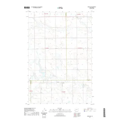
2020 Map of Cedar Lake
USGS Topo · Published 2020About this map
Cedar Lake and its surrounding wetlands serve as the focal point of this southwestern North Dakota landscape, where the borders of Slope, Hettinger, Adams, and Bowman counties converge. The hydrology of the region is defined by the branching reaches of Cedar Creek, including its northern and southern tributaries, N Cedar Cr and S Cedar Cr, as well as the flow of Chanta Peta Creek in the northeast. The survey captures a sparsely populated prairie environment structured by the Public Land Survey System, with few man-made landmarks. One notable exception is the Haven of Rest Cem, a small cemetery located south of the lake near 20th Ave NW. This map reflects the enduring rural character of the High Plains, where remote gravel roads and drainage patterns dictate the layout of the land across multiple townships.
Find a feature on this map
22 named features on this map. Tap any name to fly to it.
Don’t see what you’re looking for? This feature index may not catch every label — zoom into the map to look around manually.
Map Details
Editions of this 2020 Cedar Lake Map
This is the sole edition of this map. No revisions or reprints were ever made.
Other maps of this area

1953 · Dickinson
USGS Topo · 1:250,000

1957 · Dickinson
USGS Topo · 1:250,000

1969 · Scranton NE
USGS Topo · 1:24,000

1973 · Warnke Hill
USGS Topo · 1:24,000

1973 · Cedar Lake
USGS Topo · 1:24,000

1973 · Jung Lake
USGS Topo · 1:24,000

1973 · West Rainy Butte
USGS Topo · 1:24,000

1973 · East Rainy Butte
USGS Topo · 1:24,000

1973 · Enterprise School
USGS Topo · 1:24,000

1980 · Mott
USGS Topo · 1:100,000