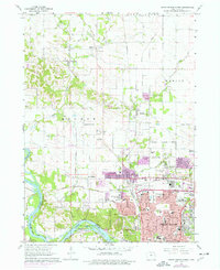
1975 Map of Cedar Rapids North
USGS Topo · Published 1976About this map
Cedar Rapids expands northward during the mid-1970s, as shown by the purple-shaded revisions indicating suburban growth around Hiawatha and Robins. The landscape transitions from the dense urban grid of neighborhoods like Kenwood and landmarks such as Mount Mercy College to the agricultural reaches of Monroe Township. Transport networks define the area, from the industrial corridors of the Illinois Central Gulf railroad to the rural crossings of West Otter Creek. Genealogists will find significant value in the documentation of several family and community burial grounds, including Squires Cem, Dunkard Cem, and the expansive Cedar Memorial Cemetery. Aviation interests are represented by local facilities like the Chain Lakes Landing Strip and the McBride Landing Strip, while the Cedar River flows through the southwest, anchoring recreational spaces such as Ellis Park.
Find a feature on this map
78 named features on this map. Tap any name to fly to it.
Don’t see what you’re looking for? This feature index may not catch every label — zoom into the map to look around manually.
Map Details
Editions of this 1975 Cedar Rapids North Map
This is the sole edition of this map. No revisions or reprints were ever made.
Other maps of this area

1887 · Cedar Rapids
USGS Topo · 1:62,500

1888 · Shellsburg
USGS Topo · 1:62,500

1888 · Marion
USGS Topo · 1:62,500

1888 · Amana
USGS Topo · 1:62,500

1889 · Marion
USGS Topo · 1:62,500

1889 · Amana
USGS Topo · 1:62,500

1889 · Shellsburg
USGS Topo · 1:62,500

1891 · Cedar Rapids
USGS Topo · 1:62,500

1899 · Amana
USGS Topo · 1:62,500

1899 · Shellsburg
USGS Topo · 1:62,500