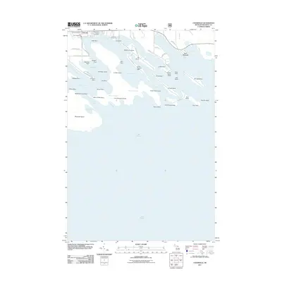
2011 Map of Cedarville
USGS Topo · Published 2011About this map
Cedarville serves as the gateway to the intricate archipelago of the Les Cheneaux Islands along the northern shore of Lake Huron. The map illustrates a landscape defined by complex water passages including the Moscoe Channel and Hill Channel, which separate landforms like Hill Island and La Salle Island from the mainland. The presence of Port Dolomite to the east indicates the region's industrial connection to the Great Lakes shipping trade, while numerous recreational sites such as Loons Point Campground and the Lazy Days Campground reflect the area's long-standing appeal for seasonal visitors and outdoorsmen.
Find a feature on this map
75 named features on this map. Tap any name to fly to it.
Don’t see what you’re looking for? This feature index may not catch every label — zoom into the map to look around manually.
Map Details
Editions of this 2011 Cedarville Map
This is the sole edition of this map. No revisions or reprints were ever made.
Other maps of this area

1931 · Pickford SE
USGS Topo · 1:31,680

1954 · Sault Sainte Marie
USGS Topo · 1:250,000

1955 · Cheboygan
USGS Topo · 1:250,000

1956 · Sault Sainte Marie
USGS Topo · 1:250,000

1957 · Sault Sainte Marie
USGS Topo · 1:250,000

1958 · Cheboygan
USGS Topo · 1:250,000

1958 · Sault Sainte Marie
USGS Topo · 1:250,000
1964 · Stalwart
USGS Topo · 1:24,000
1964 · Prentiss Bay
USGS Topo · 1:24,000
1964 · Pickford SE
USGS Topo · 1:24,000