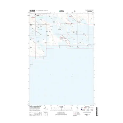
2014 Map of Cedarville
USGS Topo · Published 2014About this map
The Les Cheneaux Islands archipelago defines this coastal landscape along the northern shores of Lake Huron. The settlement of Cedarville serves as the primary gateway to a labyrinth of waterways, including the Muscoe Channel and Hill Channel. This 2014 survey reveals a transition from the structured street grid of the village to the protected lands of the Hiawatha National Forest on Government Island. Industrial activity is represented by the presence of Port Dolomite on the eastern edge of the map, connected via N Quarry Rd. The geography is characterized by narrow bays and points, such as Islington Point and Ailes Point, which create a complex shoreline that has long supported local maritime navigation and seasonal residency.
Find a feature on this map
70 named features on this map. Tap any name to fly to it.
Don’t see what you’re looking for? This feature index may not catch every label — zoom into the map to look around manually.
Map Details
Editions of this 2014 Cedarville Map
This is the sole edition of this map. No revisions or reprints were ever made.
Other maps of this area

1931 · Pickford SE
USGS Topo · 1:31,680

1954 · Sault Sainte Marie
USGS Topo · 1:250,000

1955 · Cheboygan
USGS Topo · 1:250,000

1956 · Sault Sainte Marie
USGS Topo · 1:250,000

1957 · Sault Sainte Marie
USGS Topo · 1:250,000

1958 · Cheboygan
USGS Topo · 1:250,000

1958 · Sault Sainte Marie
USGS Topo · 1:250,000
1964 · Stalwart
USGS Topo · 1:24,000
1964 · Prentiss Bay
USGS Topo · 1:24,000
1964 · Pickford SE
USGS Topo · 1:24,000