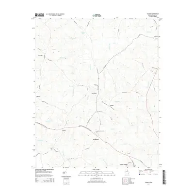
2014 Map of Celeste
USGS Topo · Published 2014About this map
New Town and the neighboring community of Celeste anchor this rural landscape in Wilkes County, where agricultural patterns are deeply etched into the Piedmont terrain. The area is defined by a dense network of watercourses, including Clark Cr and Beaverdam Cr, which flow through the undulating countryside. Infrastructure is centered around the Benjamin Wynn Forston Jr Memorial Hwy, connecting localized settlements like Brickhouse and Prather. For genealogists and local historians, the presence of the Newtown Cem and Beaverdam Cem offers tangible connection points to long-standing residents of the district. The Washington-Wilkes County Airport stands as a modern landmark amidst older geographic features such as Grimaude Lake and the former orchards near Washington-Wilkes Orchard Lake.
Find a feature on this map
60 named features on this map. Tap any name to fly to it.
Don’t see what you’re looking for? This feature index may not catch every label — zoom into the map to look around manually.
Map Details
Editions of this 2014 Celeste Map
This is the sole edition of this map. No revisions or reprints were ever made.
Other maps of this area

1906 · Crawfordville
USGS Topo · 1:125,000

1953 · Athens
USGS Topo · 1:250,000

1955 · Tignall
USGS Topo · 1:24,000

1955 · Broad
USGS Topo · 1:24,000

1958 · Athens
USGS Topo · 1:250,000

1959 · Athens
USGS Topo · 1:250,000

1963 · Athens
USGS Topo · 1:250,000

1966 · Philomath
USGS Topo · 1:24,000
1970 · Jacksons Crossroads
USGS Topo · 1:24,000
1971 · Vesta
USGS Topo · 1:24,000