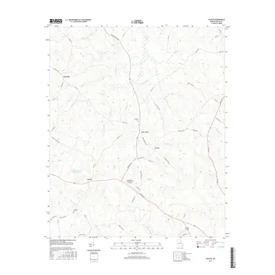
2017 Map of Celeste
USGS Topo · Published 2017About this map
New Town and Celeste anchor this rural Wilkes County landscape, where the agricultural traditions of the Georgia Piedmont meet modern aviation at the Washington-Wilkes County Airport. The terrain is defined by a dense network of tributaries including Middle Cr and Rock Cr, which carve through the undulating countryside south of Linesville. Family-named landmarks and infrastructure such as Pecan Grove Rd and Hilliard Station Rd suggest a history of orchards and rail connectivity that once shaped local commerce.
Find a feature on this map
61 named features on this map. Tap any name to fly to it.
Don’t see what you’re looking for? This feature index may not catch every label — zoom into the map to look around manually.
Map Details
Editions of this 2017 Celeste Map
This is the sole edition of this map. No revisions or reprints were ever made.
Other maps of this area

1906 · Crawfordville
USGS Topo · 1:125,000

1953 · Athens
USGS Topo · 1:250,000

1955 · Tignall
USGS Topo · 1:24,000

1955 · Broad
USGS Topo · 1:24,000

1958 · Athens
USGS Topo · 1:250,000

1959 · Athens
USGS Topo · 1:250,000

1963 · Athens
USGS Topo · 1:250,000

1966 · Philomath
USGS Topo · 1:24,000
1970 · Jacksons Crossroads
USGS Topo · 1:24,000
1971 · Vesta
USGS Topo · 1:24,000